Arniko
Chuli (6034m),
Mustang Himal again in summer. 2002
Tamotsu Ohnishi (Osaka Alpine Club)
A little
more than a hundred years ago, Sharmana Ekai Kawaguchi, the first
foreigner who had entered into Tibet through Nepal in 1900, stayed
in Mustang in advance to carry out his adventurous journey to
Lhasa. He stayed at Chharang for around ten months and eventually
decided to take an unusual route to Tibet through Dolpo, crossing
over the western mountain ranges of Mustang. (#1) In the summer
of 2001, I explored the mountain range just west of Lo Manthang
and Chharang to begin work on topographical research in this area
and stood on the top of an unnamed peak of 6270m (GPS:N29 08 41
E83 46 56). From here I expected to easily view Arniko Chuli,
13km ahead toward the WNW. However, to my regret, it proved fruitless
as the peak seemed to be among the complicated border ranges or
it was not as visible as I had previously anticipated. Later,
I found on the new topographical map of Nepal (1/50000, 2002.
No.2983-15, ARANIKO CHULI ), that the height of the peak had been
revised to 6034m.
This mysterious peak is situated at the northernmost point of
the range between Lo and Dolpo and on the international border
between Nepal and Tibet (China). It had attracted me for a long
time not only because of its considerable height, 21,650ft.(=6599m),
shown on the Indian 1inch to 1mile map(1963, 62/O/12), but also
its strange example of the nomenclature in such an uninhabited
highland. My interest was further stimulated by the fact that
no foreign travelers had ever seen this peak, nor photographed
it, and that the name Aruniko Chuli is obviously not a local Tibetan
name. I wondered why the Indian surveyors had given the peak such
a strange Nepalese name. I knew that Aruniko (or Araniko) is the
name of a famous artist or architect born in Nepal who lived in
later half of the thirteenth century and went to Tibet with other
80 Nepalese artists to design, make statues and to decorate a
large number of Buddhist gompas in Tibet and China.
My short research trip of this time planned to approach the peak
of Aruniko Chuli, from the Dolpo side and find it on the border.
Two Nepalese friends, Ang Purba and his wife Pasang Diki (Thame),
joined me with their own aspirations. We have been closely linked
for the past 20 years with mutual trust developed over many past
expeditions.
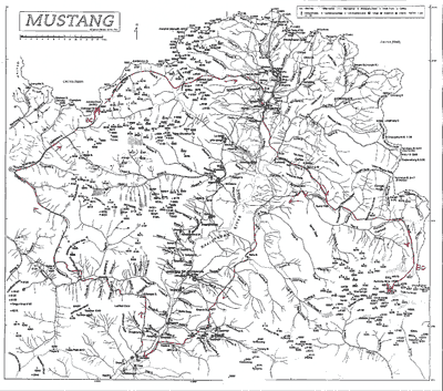
In the early afternoon of July 3, our small expedition, consisting
of only three members, a kitchen-boy and a donkey driver with
5 animals, left Jomsom at Kaligandaki. We advanced to Sangda village
along the same historical route that Ekai Kawaguchi had taken
102 years ago. After going across Geba La (GPS 4920m N28 54 904
E83 36 269), we took an alternate route toward the north along
Lhanhimar Khola which lead to a northern nameless pass (GPS 5607m,
N28 58 200 E83 25 585). Three years ago, in the same month of
July, I had had a bitter experience suffering greatly from an
unusually heavy snowfall at Tuje La on this route.
From this nameless pass, we descended along the northwestern stream
(Sano Kiraphuk Khola). The main river where we arrived at last
is shown as Chharka Tursi Khola and the upper stream of this same
river is named Nakhkhem Khola on the New Nepalese Map. We proceeded
along the broad river bed in the U shaped valley and arrived at
our base camp (GPS 5562m, N28 08 453 E83 39 526), very near Chanagor
Bhanjyang (5665m) on the northern border. We reached there on
July 8, the 6th day after we had left Jomsom. The next morning,
we climbed up the pass on the border, and enjoyed a full view
of the Tibetan side toward the north. To the west and northwest,
there are four other passes in northeastern Dolpo, namely, from
east to west, Daknak Bhanjyang (Sena La 5465m), Jyanche Bhanjyang
(5534m), Kang Kung Bhanjyang (5564m), and Pindu Bhanjyang (5600m).
The routes to Tibet from Dolpo through these five passes, all
join together at Raka Nadi (river). One of the branches of the
Tsampo basin now extended northward in front of us, the high land
with gentle slopes scarcely undulating.
In at least the eastern two passes, there was no recent trace
of local traffic or even cattle grazing. Blue poppies and other
alpine plants were amazingly abundant all over the valley. The
recent progress of Chinese motor road construction on the south
side of the Tsampo River, has speeded the decline of these passes.
Old temporary market places in Tibet beyond the Himalaya mountains
which connected with these eastern passes of Dolpo, have been
expelled and moved to more and more western places along the motor
road, which connects with western passes like Marim Bhanjyang,
Yanang Bhanjyang, Mengla Bhanjyang, Khum Bhanjyang, etc. The western
passes are closer than the eastern ones to the motor road.
On July 10th, we left BC in fine weather. From a small pokari
(pond) just below the pass, we walked up to the east and northeast
along the border ridge. After only 55 minutes climb on a gentle
rock and snow ridge, we arrived at the summit of Aruniko Chuli
.(6034m, N29 10 35 E83 39 25) at 10:.30. AM. We were among numerous
peaks a little over 6000m. From the highest point of the peak,
a vast ice field extended eastward. I stayed there about 3 hours,
doing my routine work such as making sketches and taking photographs.
As a special project at this time, I confirmed various bearing
values and the height of nearby peaks on the Nepalese New Topographical
Map (1/50000) using survey instruments. The peaks of the Man Shail
group to the northeast were not visible in the veil of the summer
clouds. We returned to BC taking another route, straight down
the scree slope of the south face of the peak. Unlike the Tibetan
side (north), the south face was completely free from snow.
We finished our research and climbed around Aruniko Chuli for
3 days, following the old direct route to Mustang from Chharka,
via Ghami Bhanjyang (5740m) to Ghami. For two days from the highest
pass to Ghami, we suffered from heavy showers of hail and rain
and had to endure a bitterly cold and miserable night in the wild
high place. We were all exhausted when we arrived at the warm
and familiar lodge at Ghami.
From Ghami, we started the second stage of activity in Damodar
Himal. Our detached party of two was ahead of us, and set up the
base camp at the northern foot of Saribung(Selibung or Soribung)
(6327m). We followed the route via Chharang, Dhi, Yara and Nakkali
Damodar Kund, a sacred place for Hindus. When we arrived at the
base camp (N28 56 50 E84 12 22), they had already pitched a high
camp at 5720m (N28 55 05 E84 10 35), on the northwest glacier
of Kumlung North Peak (6378m) . In the central part of this vast
glacier, there are the two highest peaks of Damodar Himal which
dominate the surroundings. They are Khumjungar Himal (6759m) and
Chhiv Himal (6591m), both of which had been climbed by a HAJ (Himalayan
Association of Japan) expedition in the spring of 1983. Saribung
is a neat and lovely snow peak among this group. The advance party
had started to the summit of Saribung from the high camp. Shortly
after starting, the sky became more and more threatening and when
they reached the north col of the peak, they were enveloped by
dense fog and soon fell into the whiteout trap. They completely
lost visibility and after waiting for several hours decided to
retreat.
Meanwhile, we continued the topographical research in this area,
the east glaciers of Bhrikuti Sail (6361m) and north of a nameless
eastern high peak (6899m). After that, we joined the Saribung
climbers and started the return journey to Jomsom. Enveloped by
the thick monsoon cloud, we hurried down along the Kaligandaki
River and returned to Pokhara.
(#1) The
Himalayan Journal Volume58,2002 and Supplementary papers to Japanese
Alpine News Vol.2,2002.
|